Saxons Danes & Normans

In early Anglo Saxon times, Elmet, a British (Celtic) kingdom in the Leeds/Sheffield area, held out against the invading English (Angles) to ensure that the kingdoms of Mercia and Northumbria (including Yorkshire) were formed.
Elmet eventually succumbed to become part of the Anglian kingdom of Deira.
After the invasion of William the Conquerer in 1066 Northumbria was given to Copsi, Earl of Benicia. Later Gospatric, whose name features in the Domesday book as a previously significant land owner in the area including Marton, stepped in and bought the Earldom of Northumbria from King William.
During an uprising in 1068, Gospatric (from the Cumbrian “ Servant of Saint Patrick) was defeated and lost his lands to the Norman ‘Robert Comine’, and was exiled in Scotland.
Gospatric then joined an invading army of Danes, Scots, and Englishmen under Edgar the Aetheling in 1069, and although defeated, he afterwards was able from his possession of Banburgh castle, to make terms with the Conquerer, who left him undisturbed until 1072.
Because of the numerous uprisings however, William embarked on his campaign known as the ‘Harrowing if the North’. The local inhabitants were mainly free farmers of Celtic, Angle and Danish origin, and during this campaign which consisted of a scortched earth approach to subdue the locals, an estimated 150,000 people were killed.
This was a very large number for the day, and must have had a major impact on Marton cum Grafton and environs. Evidence of this is given in the Domesday book where a greater part of Yorkshire is shown as waste.
After the 1072 campaign, Gospatric was stripped of his Earldom, and went into exile in Scotland with estates granted to him around Dunbar. He was replaced by Wallhoef.
There is no doubt that the names Marton and Grafton have a Saxon origin. The prefixes or suffixes mer/mar/mere mean a lake whilst ton/tun means an enclosed village/farmstead or manor. The origin of ‘Graf’ is not clear but it could be a persons’s name.
Domesday Extracts
Much information on land ownership etc has been published, but there is little positive information of the location of the villages at that time.
Published Domesday extracts suggest that Martone was about 1.3 km from current Marton, and its location, in respect to other villages would suggest this is in a south or south westerly direction.
The lie of certain footpaths in old maps could lead to speculation that the original village was to the south of Braimber Lane and west of Priestcarr Lane (ie west from the site of the old Church and the location of the Medieval Hall. (See Ongoing Projects - Marton's Medieval Manor)
Indeed, the name Marton is considered to derive from the word "Mere-Ton" or place by the lake.
At this stage, this can only be speculation: but the evidence appears strong:
1. The location of the Manor/church would be close to the centre of the original settlement.
2. Most of the remaining medieval Ridge & Furrow plough maarks are in the area between the old church and the Carrs, indicating that the original village fields are located here.
3. The current village houses although venerable, date from the 18th century, with only a few being placed positively in the 17th century. This indicates that the older, pre 17th century village was elsewhere.
As no physical remains of an older village have yet been positively identified (although there are still some ares to be investigated in more detail) circumstantial evidence such as the location of some finds, the location of the manor/church complex and the reference to Marton as a village near the Lake (the modern Carrs) must be regarded as significant.
The recent field survey (See Ongoing Projects - Field Survey) has indicated that most fields which appear to show evidence of Medieval (or earlier) activity are loosely centred around the area described above, and logic demands that the village would be closely associated with the Church / Manor complex.
Graftona may also had been a little way from its current centre in a northerly or north easterly direction.
Moving Houses - The Norman Period.

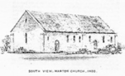
In the 18th century the Marton church was described as "Saxon...... Rebuilt in the 13th century....". This is backed up by the evidence of Rev. Lunn who recorded Saxon remains when he demolished the old curch in the late 19th century.
It is a matter of record that following one uprising too many William I (The Conquerer) ordered and participated in a scorched earth policy across Yorkshire, a policy so effective that by the time of the Domesday Survey of c.1086 over a quarter of the area was still described as wasteland.
It is perfectly feasable then that the early Saxon church, along with the original Manor, Mill and entire village was destroyed by William: Maron and Grafton's loaction almost in sight of the main road to the north would have guaranteed that the full force of Norman retribution could not have missed the villages.
This then is the reason for the village of Marton (in particular) appearing to move, and why the old church (naturally rebuilt on its original site in the 11th or 12th century) was so far from the current village. I am convinced that excavation of the area around the old church will reveal not only the saxon church but also a pre-norman village consisting of Manor, Mills and houses. Since the fields in question have since only been used as farmland there is every chance that the old villages still exist under the ground. An objective of the HIstory group has to be to do some physical investigation: shovels and muscle power willing!
