The Old Field Names Of Marton And Grafton
Old Field Names Project
The following field names have been identified from many separate sources dating from 1625 to 1855.
IIdentifying the modern field location from the old name would pinpoint the location of the arable land, homesteads and farms from the past.
This would then allow us to further identify the location of now lost properties as well as identify the loaction of the early village.
The field names are as follows: G indicates the field or farm is (or was) in Grafton and M for Marton.
If any reader can identify the modern location of any of these fields please use the "Contact Author" button on the the left hand toolbar to let me know!
In addition I have collected and collated from various sources old mfield names that can be located on a modern map. A selection of these are included below
11 Moor closes
2 Wood End Closes m
Bigghill field m
Bigill Land m
Bikewell flat m
Billy Garth m
Boltcarr Close m
Bottomes m
Bratkins Flat g
Breccon Close m
Broadgates in Carrfield m
Bykell m
Carr field m
Carr field m
Carr Field m
Carr field m
Carrfield
Carr-field m
Fandhouse Close
Gocarr Close m
Goe-Carr flat m
Goker
Goose Flatt Close m
Great Rougham m
Great Sikes
Greenaleas Close
Greenaleas Close m
Grisegill Closes m
Grysehill Closes m
Hall Croft m
Hard Myers Closes m
Hardmire Close m
Hardmires closes m
High Stainer Close
High Stainer Close
Hills Garth Close m
Hingthorn Close
Hingthorne
Hingthorne Close
Koker Dubb and in Carr Field
Lagram
Lagram Close
Lagram Field
Lagram field
Lagram field
Lagram field m
Lagram field m
Lagram Field m
Lagram Flatt in Lagram Field m
Lagramfield, m
Laygram field g
Lealandes m
Little Bykewell m
Little Priest Carr
Little Rougham m
Little Ruffam Close
Little Ruffam Close
Little Thorn Furr Close
Lockeramkells
Lockram Kells Close (formerly part of the Roose field)
Lockram Kels
Lockrum Hills
Longlands field
Lugrume Field
Moor Close
Moor Close
Moore Pasture
Mothroms Close in Marton
Mouthroms
Nodale Croft
Nodle Croft Hill
Paddock Close
Paddock Close
Paddocke Endes Pits and Roose m
Pits Flat
Pits Flat m
Pitt Close
Prescarr Close in the townfields of Marton
Priest Carr Green
Priestcar Close
Rankel Crook Close
Reeves Field
Right Carr flat
Rood field m
Roose field m
Roose field
Rougham Close (formerly part of the Carrfield)
Rougham Gaull m
Rouse field
Rouse field m
Rouse Field
Rousefield
Rousefield m
Ruffam Flatt in the Carr m
Sandhams Close
Soak Carr m
Sykes
Sykes Close
Sykes Close m
the four Moor Closes m
the Paddock
the Tofts
Thistlebarfield
Thornfurr Close
Thornfurs Close
Toft Close m
Tofts flat m
Townend Carr
Townend Close
Townend Close
Townend field m
Townend Hill
Ward Garth
Watersea Flat in Bramebar Field
Watersea in the Carr Field
Watersey
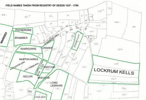
In addition I have collected and collated from various sources old mfield names that can be located on a modern map. A selection of these are included above. Click on the images to enlarge, AND FEEL FREE TO CORRECT ME IF THEY ARE WRONG!
